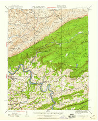
1932 Map of Pearisburg
USGS Topo · Published 1959About this map
The New River carves a winding path through the heart of the Appalachian landscape in this early 1930s survey, marking a corridor of intense transport and settlement between Pearisburg and Eggleston. The river banks host competing rail lines, the Norfolk and Western Ry and the Virginian Ry, which connect industrial outposts like Goldbond and Kimballton to the wider region. In the highlands, the presence of Mountain Lake serves as a distinct landmark amidst the ridges of Butt Mountain and Doe Mountain. The map reveals a deeply social landscape of the era, defined by combined community hubs such as the Oak Hill School & Church and the Coulter Chapel School & Church. Further north, the Salt Sulphur Turnpike traces an older route of travel through Lindside, illustrating the transition from traditional turnpikes to the rail-dominated economy of the early twentieth century.
Find a feature on this map
120 named features on this map. Tap any name to fly to it.
Don’t see what you’re looking for? This feature index may not catch every label — zoom into the map to look around manually.
Map Details
Editions of this 1932 Pearisburg Map
3 editions found

Other maps of this area

1887 · Hinton
USGS Topo · 1:125,000

1887 · Lewisburg
USGS Topo · 1:125,000

1890 · Dublin
USGS Topo · 1:125,000

1890 · Christiansburg
USGS Topo · 1:125,000

1891 · Lewisburg
USGS Topo · 1:125,000

1891 · Dublin
USGS Topo · 1:125,000

1892 · Hinton
USGS Topo · 1:125,000

1912 · Big Bend
USGS Topo · 1:62,500

1913 · Peterstown
USGS Topo · 1:48,000

1914 · Big Bend
USGS Topo · 1:62,500