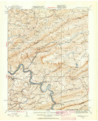
1932 Map of Pearisburg
USGS Topo · Published 1959About this map
The New River carves a dramatic path through the center of this 1930s landscape, serving as the primary corridor for the Norfolk and Western railroad. This industrial and transportation artery links the county seat of Pearisburg with riverside settlements like Ripplemead, Pembroke, and Eggleston. The map reveals a high density of rural institutions that sustained these mountain communities, including the Flatwoods Church, Hoges Store, and the Chestnut Grove School. Higher elevations are defined by the presence of Mountain Lake, situated beneath the peaks of Salt Pond Mountain. The intricate network of small schools, such as Dry Pond School and Shires School, underscores the localized nature of social life before mid-century consolidation. From the limestone operations at Ripplemead to the ridge-top gaps like Dickinson Gap, the topography reflects a region where geology dictated both settlement and passage.
Find a feature on this map
121 named features on this map. Tap any name to fly to it.
Don’t see what you’re looking for? This feature index may not catch every label — zoom into the map to look around manually.
Map Details
Editions of this 1932 Pearisburg Map
3 editions found

Other maps of this area

1887 · Hinton
USGS Topo · 1:125,000

1887 · Lewisburg
USGS Topo · 1:125,000

1890 · Dublin
USGS Topo · 1:125,000

1890 · Christiansburg
USGS Topo · 1:125,000

1891 · Lewisburg
USGS Topo · 1:125,000

1891 · Dublin
USGS Topo · 1:125,000

1892 · Hinton
USGS Topo · 1:125,000

1912 · Big Bend
USGS Topo · 1:62,500

1913 · Peterstown
USGS Topo · 1:48,000

1914 · Big Bend
USGS Topo · 1:62,500