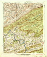
1937 Map of Pearisburg
USGS Topo · Published 1937About this map
Pearisburg and the winding course of the New River anchor this 1930s landscape, where industrial infrastructure meets the high ridges of the Alleghenies. The Norfolk and Western Ry snakes along the riverbank, serving river towns like Pembroke and Eggleston while passing beneath the looming shadow of Peters Mountain. This survey captures the region just as the Blue Grass Trail and other early highways were beginning to formalize the transport network through the gaps.
Find a feature on this map
102 named features on this map. Tap any name to fly to it.
Don’t see what you’re looking for? This feature index may not catch every label — zoom into the map to look around manually.
Map Details
Editions of this 1937 Pearisburg Map
3 editions found

Other maps of this area

1887 · Hinton
USGS Topo · 1:125,000

1887 · Lewisburg
USGS Topo · 1:125,000

1890 · Dublin
USGS Topo · 1:125,000

1890 · Christiansburg
USGS Topo · 1:125,000

1891 · Lewisburg
USGS Topo · 1:125,000

1891 · Dublin
USGS Topo · 1:125,000

1892 · Hinton
USGS Topo · 1:125,000

1912 · Big Bend
USGS Topo · 1:62,500

1913 · Peterstown
USGS Topo · 1:48,000

1914 · Big Bend
USGS Topo · 1:62,500