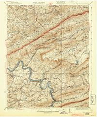
1937 Map of Pearisburg
USGS Topo · Published 1944About this map
New River meanders deeply through the center of this terrain, its course tightly followed by the Norfolk and Western Ry as it passes through Pearisburg and Pembroke. This 1930s survey captures a landscape of intense relief, where industrial rail infrastructure at the river's edge contrasts with high-altitude landmarks like Mountain Lake and the precipitous Cascades. The map reveals a dense network of mountain schools and churches, such as Swope School and Lucas Memorial Church, indicating a settled backcountry life tucked into the gaps of Peters Mountain and Doe Mountain. The inclusion of various "Abandoned" road segments and historic routes like the Turnpike north of Lindside provides a look at the shifting transportation patterns of the early twentieth century, while family-named locales like Hoges Store and Goodwins Ferry mark the economic hubs of the rural river valley.
Find a feature on this map
128 named features on this map. Tap any name to fly to it.
Don’t see what you’re looking for? This feature index may not catch every label — zoom into the map to look around manually.
Map Details
Editions of this 1937 Pearisburg Map
3 editions found

Other maps of this area

1887 · Hinton
USGS Topo · 1:125,000

1887 · Lewisburg
USGS Topo · 1:125,000

1890 · Dublin
USGS Topo · 1:125,000

1890 · Christiansburg
USGS Topo · 1:125,000

1891 · Lewisburg
USGS Topo · 1:125,000

1891 · Dublin
USGS Topo · 1:125,000

1892 · Hinton
USGS Topo · 1:125,000

1912 · Big Bend
USGS Topo · 1:62,500

1913 · Peterstown
USGS Topo · 1:48,000

1914 · Big Bend
USGS Topo · 1:62,500