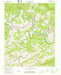
1965 Map of Pearisburg
USGS Topo · Published 1979About this map
New River loops through the heart of Giles County, carving a deep path between Butt Mountain and Guinea Mountain. This 1965 survey, updated in the late 1970s, captures the industrial and community center of Pearisburg, where the Norfolk and Western railroad tracks follow the river's bend past Bluff City and Ripplemead. The valley floor is punctuated by local landmarks like the Giles Mem Hospital and the Drive-in Theater, while the heights are traversed by the Appalachian Trail.
Find a feature on this map
50 named features on this map. Tap any name to fly to it.
Don’t see what you’re looking for? This feature index may not catch every label — zoom into the map to look around manually.
Map Details
Editions of this 1965 Pearisburg Map
Other maps of this area

1890 · Dublin
USGS Topo · 1:125,000

1891 · Dublin
USGS Topo · 1:125,000

1913 · Peterstown
USGS Topo · 1:48,000

1916 · Peterstown
USGS Topo · 1:62,500

1923 · Pearisburg
USGS Topo · 1:62,500

1925 · Peterstown
USGS Topo · 1:62,500

1932 · Peterstown
USGS Topo · 1:48,000

1932 · Pearisburg
USGS Topo · 1:48,000

1934 · Pulaski
USGS Topo · 1:48,000

1937 · Pearisburg
USGS Topo · 1:62,500