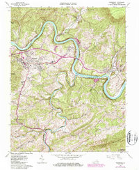
1965 Map of Pearisburg
USGS Topo · Published 1987About this map
The New River carves a sweeping path through the heart of Giles County, defining the industrial and civic layout of Pearisburg and its surrounding communities. The mid-1960s landscape is anchored by the Norfolk and Western railway, which follows the river's winding course to serve local industries, including a prominent Quarry near Ripplemead and Klotz. This map captures the town of Pearisburg as a regional hub, featuring the Giles Mem Hospital, Giles High Sch, and the local Drive-in Theater. To the east and south, the terrain rises sharply toward Butt Mountain and Rich Mountain, where the boundaries of the Jefferson National Forest meet small agrarian settlements like Bane and Mountain View. For genealogists, the map preserves the locations of rural landmarks such as the Mason-French Cem and the Bane Sch along the banks of Walker Creek.
Find a feature on this map
43 named features on this map. Tap any name to fly to it.
Don’t see what you’re looking for? This feature index may not catch every label — zoom into the map to look around manually.
Map Details
Editions of this 1965 Pearisburg Map
Other maps of this area

1890 · Dublin
USGS Topo · 1:125,000

1891 · Dublin
USGS Topo · 1:125,000

1913 · Peterstown
USGS Topo · 1:48,000

1916 · Peterstown
USGS Topo · 1:62,500

1923 · Pearisburg
USGS Topo · 1:62,500

1925 · Peterstown
USGS Topo · 1:62,500

1932 · Peterstown
USGS Topo · 1:48,000

1932 · Pearisburg
USGS Topo · 1:48,000

1934 · Pulaski
USGS Topo · 1:48,000

1937 · Pearisburg
USGS Topo · 1:62,500