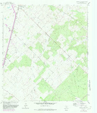
1964 Map of Pearsall South
USGS Topo · Published 1982About this map
Pearsall anchors the northern edge of this South Texas landscape, where the Missouri Pacific railroad cuts a straight line south toward the settlement of Melon. The terrain is defined by a network of drainage ways and working land, including Lockhardt Creek and Mule Creek, punctuated by industrial and agricultural markers. Significant infrastructure of the mid-20th century is evident, such as the Drive-in Theater near the town center and the McKinley Airfield further south.
Find a feature on this map
18 named features on this map. Tap any name to fly to it.
Don’t see what you’re looking for? This feature index may not catch every label — zoom into the map to look around manually.
Map Details
Editions of this 1964 Pearsall South Map
2 editions found
Other maps of this area

1925 · Pearsall 1-b
USGS Topo · 1:48,000

1925 · Pearsall 1-c
USGS Topo · 1:48,000

1927 · Pearsall
USGS Topo · 1:62,500

1934 · Schattel
USGS Topo · 1:62,500

1942 · Dilley
USGS Topo · 1:62,500

1953 · Crystal City
USGS Topo · 1:250,000

1955 · Crystal City
USGS Topo · 1:250,000

1956 · Hindes
USGS Topo · 1:62,500

1961 · Crystal City
USGS Topo · 1:250,000

1964 · Pearsall South
USGS Topo · 1:24,000