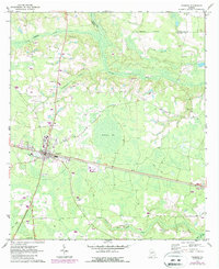
1971 Map of Pearson
USGS Topo · Published 1987About this map
Pearson serves as the focal point of this coastal plain survey, situated where the CSX railroad corridor bisects the flatwoods landscape of Atkinson County. The town layout is clearly defined, showing the Jr High Sch and several local landmarks, including the Roadside Park on the western edge. Beyond the town limits, the geography is characterized by intricate wetlands and drainage systems such as Pudding Creek, Sweetwater Creek, and the Satilla River. The interior is marked by the expansive Ricketson Bay, a notable topographical depression common to this region of Georgia.
Find a feature on this map
19 named features on this map. Tap any name to fly to it.
Don’t see what you’re looking for? This feature index may not catch every label — zoom into the map to look around manually.
Map Details
Editions of this 1971 Pearson Map
2 editions found
Other maps of this area

1953 · Waycross
USGS Topo · 1:250,000

1958 · Waycross
USGS Topo · 1:250,000

1968 · Cogdell
USGS Topo · 1:24,000

1971 · Douglas South
USGS Topo · 1:24,000

1971 · Wilsonville
USGS Topo · 1:24,000

1971 · Axson
USGS Topo · 1:24,000

1971 · Pearson
USGS Topo · 1:24,000

1972 · Kirkland
USGS Topo · 1:24,000

1972 · Sandy Bottom
USGS Topo · 1:24,000

1972 · Henderson Still
USGS Topo · 1:24,000