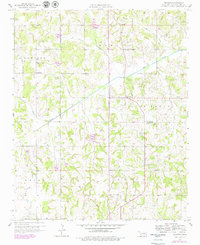
1958 Map of Pearson
USGS Topo · Published 1979About this map
St Louis Oil Field operations define the economy of this central Oklahoma landscape during the late 1950s, with numerous Oil Wells and a central Pumping Station punctuating the rural terrain. Small community hubs like Pearson and Anderson serve as local anchors, each supported by civic institutions such as the Anderson Sch and the Cloverdale Sch. The settlement pattern is deeply rooted in local history, evidenced by a series of significant family and community landmarks including the Romulus Cem, Pearson Cem, and Avoca Cem.
Find a feature on this map
24 named features on this map. Tap any name to fly to it.
Don’t see what you’re looking for? This feature index may not catch every label — zoom into the map to look around manually.
Map Details
Editions of this 1958 Pearson Map
3 editions found
Other maps of this area

1896 · Seminole and Prague
USGS Topo · 1:125,000

1898 · Purcell
USGS Topo · 1:125,000

1898 · Pauls Valley
USGS Topo · 1:125,000

1901 · Stonewall
USGS Topo · 1:125,000

1902 · Pauls Valley
USGS Topo · 1:125,000

1907 · Maud
USGS Topo · 1:62,500

1908 · Maud
USGS Topo · 1:62,500

1910 · McComb
USGS Topo · 1:62,500

1954 · Oklahoma City
USGS Topo · 1:250,000

1957 · Ardmore
USGS Topo · 1:250,000