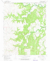
1973 Map of Pearsonia NE
USGS Topo · Published 1975About this map
Hulah Lake dominates the northern landscape of this 1973 survey, a reservoir formed along the winding Caney River just south of the Oklahoma-Kansas state line. The terrain within Osage County is characterized by extensive energy extraction, with a widespread Oil Field and numerous Oil Wells, Oil Well sites, and a Gas Well dotting the hillsides. These industrial features are interspersed among a dense network of watercourses including Buck Creek, Pond Creek, and North Fox Creek. The map provides a clear look at the Indian Reservation Boundary as it intersects the river valley, marking a landscape where the mid-century petroleum economy was superimposed upon older tribal lands and rugged drainage basins.
Find a feature on this map
17 named features on this map. Tap any name to fly to it.
Don’t see what you’re looking for? This feature index may not catch every label — zoom into the map to look around manually.
Map Details
Editions of this 1973 Pearsonia NE Map
This is the sole edition of this map. No revisions or reprints were ever made.
Other maps of this area

1885 · Sedan
USGS Topo · 1:125,000

1889 · Sedan
USGS Topo · 1:125,000

1909 · Pawhuska
USGS Topo · 1:125,000

1910 · Pawhuska
USGS Topo · 1:125,000

1955 · Wichita
USGS Topo · 1:250,000

1955 · Enid
USGS Topo · 1:250,000

1958 · Enid
USGS Topo · 1:250,000

1958 · Wichita
USGS Topo · 1:250,000

1960 · Nanos
USGS Topo · 1:24,000

1960 · Herd
USGS Topo · 1:24,000