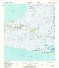
1951 Map of Pecan Island
USGS Topo · Published 1962About this map
White Lake and the vast marshlands of Vermilion Parish dominate this early 1950s coastal survey, where narrow ridges provide the only solid ground for settlement and industry. The community of Pecan Island stretches along the central cheniers, featuring a cemetery, a water tank, and several homes situated along Back Ridge and Front Ridge. These elevated shell and sand ridges, including Lambert Ridge and Sweet Bay Ridge, represent a distinctive coastal geomorphology that has historically dictated human habitation in the Louisiana wetlands.
Find a feature on this map
49 named features on this map. Tap any name to fly to it.
Don’t see what you’re looking for? This feature index may not catch every label — zoom into the map to look around manually.
Map Details
Editions of this 1951 Pecan Island Map
5 editions found

Other maps of this area

1932 · Abbeville SW
USGS Topo · 1:31,680

1932 · Constance Bayou NE
USGS Topo · 1:31,680

1932 · Pecan Island SE
USGS Topo · 1:31,680

1932 · Pecan Island SW
USGS Topo · 1:31,680

1932 · Constance Bayou SE
USGS Topo · 1:31,680

1945 · Pecan Island NW
USGS Topo · 1:31,680

1945 · Pecan Island NE
USGS Topo · 1:31,680

1946 · Redfish Point SW
USGS Topo · 1:31,680

1946 · Schooner Bayou SE
USGS Topo · 1:31,680

1946 · Redfish Point NW
USGS Topo · 1:31,680