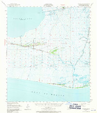
1951 Map of Pecan Island
USGS Topo · Published 1971About this map
The coastal ridges of Vermilion Parish dominate this 1951 field survey, where the linear settlement of Pecan Island follows a narrow strip of high ground between the marsh and White Lake. The landscape is a complex network of natural waterways and man-made infrastructure, featuring numerous family-named landforms such as Cypress Point Ridge, Sweet Bay Ridge, and Lambert Ridge. These ridges provided vital habitable land in a region otherwise defined by expansive wetlands and water bodies like Schooner Bayou.
Find a feature on this map
50 named features on this map. Tap any name to fly to it.
Don’t see what you’re looking for? This feature index may not catch every label — zoom into the map to look around manually.
Map Details
Editions of this 1951 Pecan Island Map
5 editions found

Other maps of this area

1932 · Abbeville SW
USGS Topo · 1:31,680

1932 · Constance Bayou NE
USGS Topo · 1:31,680

1932 · Pecan Island SE
USGS Topo · 1:31,680

1932 · Pecan Island SW
USGS Topo · 1:31,680

1932 · Constance Bayou SE
USGS Topo · 1:31,680

1945 · Pecan Island NW
USGS Topo · 1:31,680

1945 · Pecan Island NE
USGS Topo · 1:31,680

1946 · Redfish Point SW
USGS Topo · 1:31,680

1946 · Schooner Bayou SE
USGS Topo · 1:31,680

1946 · Redfish Point NW
USGS Topo · 1:31,680