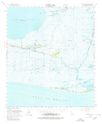
1951 Map of Pecan Island
USGS Topo · Published 1980About this map
Chenier ridges dominate this coastal landscape, providing the only high ground for human habitation above the marshes of Vermilion Parish. The settlement of Pecan Island stretches along a series of these narrow elevations, including Back Ridge and Front Ridge, where the local Cem serves as a genealogical marker for the community. In this early 1950s survey, the transition from a remote agricultural and trapping outpost to an industrial zone is evident as an Oil Field and numerous Oil Wells appear near White Lake.
Find a feature on this map
50 named features on this map. Tap any name to fly to it.
Don’t see what you’re looking for? This feature index may not catch every label — zoom into the map to look around manually.
Map Details
Editions of this 1951 Pecan Island Map
5 editions found

Other maps of this area

1932 · Abbeville SW
USGS Topo · 1:31,680

1932 · Constance Bayou NE
USGS Topo · 1:31,680

1932 · Pecan Island SE
USGS Topo · 1:31,680

1932 · Pecan Island SW
USGS Topo · 1:31,680

1932 · Constance Bayou SE
USGS Topo · 1:31,680

1945 · Pecan Island NW
USGS Topo · 1:31,680

1945 · Pecan Island NE
USGS Topo · 1:31,680

1946 · Redfish Point SW
USGS Topo · 1:31,680

1946 · Schooner Bayou SE
USGS Topo · 1:31,680

1946 · Redfish Point NW
USGS Topo · 1:31,680