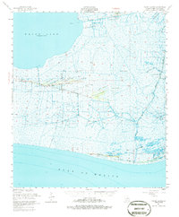
1951 Map of Pecan Island
USGS Topo · Published 1986About this map
Pecan Island rises above the marshlands of Vermilion Parish, anchoring a coastal landscape defined by narrow ridges and an intricate network of waterways. This 1951 survey, based on aerial photography from the late 1940s, reveals a mid-century coastal economy where established settlements like Front Ridge sit adjacent to an emerging Oil Field. The Louisiana coast is characterized here by a series of elongated cheniers—ridges of oak and shell that provided the only stable ground for habitation and agriculture—including Sweet Bay Ridge, Cane Ridge, and Lambert Ridge.
Find a feature on this map
42 named features on this map. Tap any name to fly to it.
Don’t see what you’re looking for? This feature index may not catch every label — zoom into the map to look around manually.
Map Details
Editions of this 1951 Pecan Island Map
5 editions found

Other maps of this area

1932 · Abbeville SW
USGS Topo · 1:31,680

1932 · Constance Bayou NE
USGS Topo · 1:31,680

1932 · Pecan Island SE
USGS Topo · 1:31,680

1932 · Pecan Island SW
USGS Topo · 1:31,680

1932 · Constance Bayou SE
USGS Topo · 1:31,680

1945 · Pecan Island NW
USGS Topo · 1:31,680

1945 · Pecan Island NE
USGS Topo · 1:31,680

1946 · Redfish Point SW
USGS Topo · 1:31,680

1946 · Schooner Bayou SE
USGS Topo · 1:31,680

1946 · Redfish Point NW
USGS Topo · 1:31,680