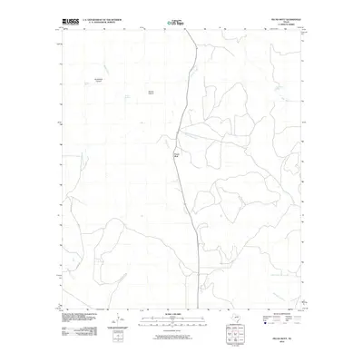
2010 Map of Pecan Mott
USGS Topo · Published 2010About this map
Pecan Mott serves as the central focal point of this arid landscape in West Texas, situated in an area where water sources historically dictated settlement and survival. Numerous drainages such as Red Creek and Liveoak Creek carve through the terrain, leading toward significant landmarks like Butterfield Canyon and Spring Canyon. The map identifies several vital water points, including Buffalo Spring, Houston Springs, and Mule Creek Spring, which underscore the region's reliance on reliable spring-fed locations. This 2010 survey illustrates a network of local ranch roads, including Sutton Rd, connecting remote parts of Coke County across a landscape of seasonal creeks like Crows Nest Creek and Bald Eagle Creek. The density of named springs and canyons suggests a landscape shaped by both cattle ranching traditions and the geographical demands of the Concho Valley region.
Find a feature on this map
15 named features on this map. Tap any name to fly to it.
Don’t see what you’re looking for? This feature index may not catch every label — zoom into the map to look around manually.
Map Details
Editions of this 2010 Pecan Mott Map
This is the sole edition of this map. No revisions or reprints were ever made.
Other maps of this area

1891 · Hayrick
USGS Topo · 1:125,000

1894 · Hayrick
USGS Topo · 1:125,000

1921 · Mays School
USGS Topo · 1:31,680

1954 · San Angelo
USGS Topo · 1:250,000

1957 · Carlsbad
USGS Topo · 1:62,500

1957 · Harriet
USGS Topo · 1:62,500

1957 · Mount Nebo
USGS Topo · 1:24,000
1957 · San Angelo North
USGS Topo · 1:24,000

1958 · San Angelo
USGS Topo · 1:250,000
1961 · Shawville
USGS Topo · 1:24,000