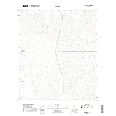
2019 Map of Pecan Mott
USGS Topo · Published 2019About this map
Butterfield Canyon and Spring Canyon dominate the northern landscape of this Texas ranching country, where water sources are vital enough to be individually named. The drainage patterns of Buffalo Creek and Red Creek highlight the natural pathways through the terrain of Coke County and Tom Green County. Scattered water features like Buffalo Spring, Houston Springs, and Mule Creek Spring indicate the essential points for livestock and human survival in this arid environment. Transportation is limited to sparse routes such as Sutton Road and Mount Road, reflecting the low-density, rural character of the region. Local hydrology is further detailed by Crows Nest Creek, its smaller counterpart Little Crows Nest Creek, and the seasonal flow of Valentine Branch.
Find a feature on this map
16 named features on this map. Tap any name to fly to it.
Don’t see what you’re looking for? This feature index may not catch every label — zoom into the map to look around manually.
Map Details
Editions of this 2019 Pecan Mott Map
This is the sole edition of this map. No revisions or reprints were ever made.
Other maps of this area

1891 · Hayrick
USGS Topo · 1:125,000

1894 · Hayrick
USGS Topo · 1:125,000

1921 · Mays School
USGS Topo · 1:31,680

1954 · San Angelo
USGS Topo · 1:250,000

1957 · Carlsbad
USGS Topo · 1:62,500

1957 · Harriet
USGS Topo · 1:62,500

1957 · Mount Nebo
USGS Topo · 1:24,000
1957 · San Angelo North
USGS Topo · 1:24,000

1958 · San Angelo
USGS Topo · 1:250,000
1961 · Shawville
USGS Topo · 1:24,000