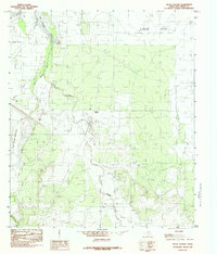
1984 Map of Pecan Station
USGS Topo · Published 1984About this map
The South Concho River snakes through this West Texas landscape, feeding into the southern reaches of Lake Nasworthy and the expansive Twin Buttes Reservoir. This mid-1980s provisional survey illustrates a transition from the structured airfield of Mathis Field and a nearby Golf Course to the open ranching and agricultural expanse of Lipan Flat. The settlement of Pecan Station serves as a local landmark along the watercourse of Pecan Creek, which drains toward the main river system.
Find a feature on this map
14 named features on this map. Tap any name to fly to it.
Don’t see what you’re looking for? This feature index may not catch every label — zoom into the map to look around manually.
Map Details
Editions of this 1984 Pecan Station Map
This is the sole edition of this map. No revisions or reprints were ever made.
Other maps of this area

1892 · San Angelo
USGS Topo · 1:125,000

1895 · Sherwood
USGS Topo · 1:125,000

1924 · San Angelo 2-c
USGS Topo · 1:48,000

1924 · Sherwood 1-d
USGS Topo · 1:48,000

1924 · San Angelo 2-b
USGS Topo · 1:48,000

1924 · Sherwood 1-a
USGS Topo · 1:48,000

1928 · Wall
USGS Topo · 1:62,500

1928 · Tankersly
USGS Topo · 1:62,500

1954 · San Angelo
USGS Topo · 1:250,000

1957 · Twin Buttes
USGS Topo · 1:24,000