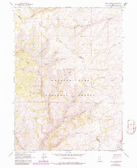
1968 Map of Peck Canyon
USGS Topo · Published 1986About this map
The Wasatch Ridge dominates the skyline of this high-elevation terrain within the Wasatch-Cache National Forest, marking the watershed between the Morgan and Rich county lines. The landscape is defined by a dense network of watercourses, including Lost Creek, Beaver Creek, and Sawmill Creek, which have carved deep drainages like Meachum Canyon and Peck Canyon into the mountain flanks. These named canyons and ridges, such as Condie Ridge and Blue Ridge, indicate a history of local land use tied to livestock grazing and timber, with numerous springs scattered throughout to support movement across the heights.
Find a feature on this map
19 named features on this map. Tap any name to fly to it.
Don’t see what you’re looking for? This feature index may not catch every label — zoom into the map to look around manually.
Map Details
Editions of this 1968 Peck Canyon Map
3 editions found

Other maps of this area

1954 · Ogden
USGS Topo · 1:250,000

1958 · Ogden
USGS Topo · 1:250,000

1960 · Ogden
USGS Topo · 1:250,000

1964 · Lost Creek Dam
USGS Topo · 1:24,000

1964 · Francis Canyon
USGS Topo · 1:24,000

1968 · Horse Ridge
USGS Topo · 1:24,000

1968 · Dairy Ridge
USGS Topo · 1:24,000

1968 · Shearing Corral
USGS Topo · 1:24,000

1968 · Mc Kay Hollow
USGS Topo · 1:24,000

1968 · Meachum Ridge
USGS Topo · 1:24,000