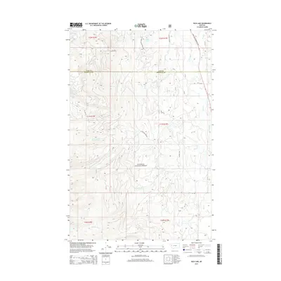
2014 Map of Peck Lake
USGS Topo · Published 2014About this map
The Flathead National Forest encompasses the vast majority of this landscape along the boundary of Lake and Missoula counties. The topography is defined by the drainage basins of the Swan River and its numerous tributaries, including Cold Creek and Jim Creek. A key navigational and historical landmark, the Jim Creek Lookout Tower, stands prominently overlooking the Jim Creek drainage, a reminder of the region's fire management history. In the northeastern corner, the Daryl Sortesz Memorial Hwy provides the primary transit corridor through the valley, paralleled by the Swan River. To the west, the terrain rises sharply toward higher elevations, accessible by specialized routes like Jim Lake Rd and Natl Forest Develop Road 888 Rd. The map also captures several high-altitude water bodies, including Peck Lake and Jim Lake, which anchor the surrounding network of forest service roads and local tracks.
Find a feature on this map
22 named features on this map. Tap any name to fly to it.
Don’t see what you’re looking for? This feature index may not catch every label — zoom into the map to look around manually.
Map Details
Editions of this 2014 Peck Lake Map
This is the sole edition of this map. No revisions or reprints were ever made.
Other maps of this area

1921 · Elbow Lake
USGS Topo · 1:125,000

1955 · Choteau
USGS Topo · 1:250,000

1957 · Choteau
USGS Topo · 1:250,000

1958 · Choteau
USGS Topo · 1:250,000

1962 · Choteau
USGS Topo · 1:250,000

1965 · Peck Lake
USGS Topo · 1:24,000

1965 · Condon
USGS Topo · 1:24,000

1965 · Swan Peak
USGS Topo · 1:24,000
1965 · Piper-Crow Pass
USGS Topo · 1:24,000
1965 · Cygnet Lake
USGS Topo · 1:24,000