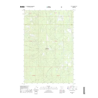
2020 Map of Peck Lake
USGS Topo · Published 2020About this map
The Mission Range defines the western reaches of this high-country landscape within the Flathead National Forest. This terrain is characterized by a complex network of glacial lakes and steep ridges, including Elk Ridge and the prominent Elk Creek Point in the south. The hydrography of the region is anchored by the Swan River, which flows through the eastern corridor, receiving waters from Dog Cr and Condon Cr. Smaller alpine features like Peck Lake, Jim Lake, and the Cold Lakes are tucked into the mountainous folds, connected by seasonal drainages such as N Fork Cold Cr and S Fork Cold Cr. Access to these remote elevations is maintained through a series of specialized routes like Peck Lake Rd and Elk Flats Rd, which trace the difficult topography across the boundary between Lake and Missoula counties.
Find a feature on this map
32 named features on this map. Tap any name to fly to it.
Don’t see what you’re looking for? This feature index may not catch every label — zoom into the map to look around manually.
Map Details
Editions of this 2020 Peck Lake Map
This is the sole edition of this map. No revisions or reprints were ever made.
Other maps of this area

1921 · Elbow Lake
USGS Topo · 1:125,000

1955 · Choteau
USGS Topo · 1:250,000

1957 · Choteau
USGS Topo · 1:250,000

1958 · Choteau
USGS Topo · 1:250,000

1962 · Choteau
USGS Topo · 1:250,000

1965 · Peck Lake
USGS Topo · 1:24,000

1965 · Condon
USGS Topo · 1:24,000

1965 · Swan Peak
USGS Topo · 1:24,000
1965 · Piper-Crow Pass
USGS Topo · 1:24,000
1965 · Cygnet Lake
USGS Topo · 1:24,000