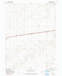
1969 Map of Peconic
USGS Topo · Published 1991About this map
The settlement of Peconic sits as a lonely outpost along the eastern plains of Kit Carson County, anchored by the Chicago Rock Island and Pacific railroad line. This survey, conducted in the late 1960s, reveals a landscape defined by its vital water sources and transportation infrastructure. Numerous groundwater Wells are scattered across the terrain, reflecting the reliance on sub-surface irrigation for the region's agricultural survival. The local topography is carved by the drainages of Little Beaver Creek, Middle Beaver Creek, and Sand Creek, which wind through the township lines of T 8 S and T 9 S. Travelers along the primary roadway would have found a brief respite at Roadside Park, while the local economy is punctuated by several Gravel Pits, indicating the small-scale extraction of materials for regional road maintenance and construction.
Find a feature on this map
11 named features on this map. Tap any name to fly to it.
Don’t see what you’re looking for? This feature index may not catch every label — zoom into the map to look around manually.
Map Details
Editions of this 1969 Peconic Map
3 editions found
Other maps of this area

1954 · Limon
USGS Topo · 1:250,000

1957 · Limon
USGS Topo · 1:250,000

1958 · Limon
USGS Topo · 1:250,000

1969 · Kanorado NE
USGS Topo · 1:24,000

1969 · Burlington
USGS Topo · 1:24,000

1969 · Mount Sunflower NW
USGS Topo · 1:24,000
1969 · Mount Sunflower NE
USGS Topo · 1:24,000

1969 · Peconic
USGS Topo · 1:24,000

1969 · Kanorado NW
USGS Topo · 1:24,000
1969 · Burlington NE
USGS Topo · 1:24,000