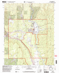
2002 Map of Pecos
USGS Topo · Published 2003About this map
The Pecos River valley serves as the central artery for this northern New Mexico landscape, where spiritual, industrial, and ancient histories converge. The Benedictine Monastery and Monastery Lake sit just north of the village of Pecos, while the industrial legacy of the region is marked by the Terrero Mill (Site) and associated Tailings Pond along Alamitos Creek. The southern portion of the sheet is dominated by the Pecos National Historic Park, protecting significant Ruins and the Visitors Center near the path of the Glorieta Pass Historic Trail. Further south, the map details the transition into the Los Trigos Grant, where the Forked Lightning Ranch House and a local Trading Post are situated near the riverbanks. Diverse terrain features like Cerro de Escobas and the massive Glorieta Mesa frame the valley's cultural and ecological sites, including the Lisboa Springs Fish Hatchery.
Find a feature on this map
45 named features on this map. Tap any name to fly to it.
Don’t see what you’re looking for? This feature index may not catch every label — zoom into the map to look around manually.
Map Details
Editions of this 2002 Pecos Map
2 editions found
Other maps of this area

1889 · Santa Fe
USGS Topo · 1:125,000

1894 · Santa Fe
USGS Topo · 1:125,000

1894 · Lamy
USGS Topo · 1:125,000

1953 · Glorieta
USGS Topo · 1:24,000

1953 · Mc Clure Reservoir
USGS Topo · 1:24,000

1954 · Santa Fe
USGS Topo · 1:250,000

1958 · Santa Fe
USGS Topo · 1:250,000

1961 · Honey Boy Ranch
USGS Topo · 1:24,000

1961 · Rosilla Peak
USGS Topo · 1:24,000
1961 · Pecos
USGS Topo · 1:24,000