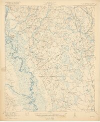
1920 Map of Peeples
USGS Topo · Published 1920About this map
The Savannah River defines the western edge of this 1918 survey, carving a complex path marked by distinctive river points like Wildcat Pt and Saucy Boy Pt. This lowcountry landscape in Allendale, South Carolina, is characterized by its numerous small river landings, including Cohens Bluff Ldg and Red Bluff Ldg, which served as vital transport nodes before modern road networks dominated. Inland, the map reveals a dense network of country churches and schools that anchored rural life, such as the Buddenville School and Virgin Mary Church.
Find a feature on this map
81 named features on this map. Tap any name to fly to it.
Don’t see what you’re looking for? This feature index may not catch every label — zoom into the map to look around manually.
Map Details
Editions of this 1920 Peeples Map
3 editions found
Other maps of this area

1918 · Varnville
USGS Topo · 1:62,500

1918 · Oliver
USGS Topo · 1:62,500

1919 · Pineland
USGS Topo · 1:62,500

1919 · Olar
USGS Topo · 1:62,500

1919 · Shirley
USGS Topo · 1:62,500

1919 · Allendale
USGS Topo · 1:62,500

1920 · Ellenton
USGS Topo · 1:48,000

1920 · Hilltonia
USGS Topo · 1:62,500

1920 · Oliver
USGS Topo · 1:62,500

1920 · Peeples
USGS Topo · 1:62,500