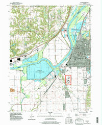
1996 Map of Pekin
USGS Topo · Published 1997About this map
The Illinois River serves as the dominant geographic and economic spine of this mid-1990s survey, dividing the landscape between the industrial and residential grid of Pekin and the low-lying wetlands of the west bank. Large-scale water management and industrial infrastructure are evident, notably the massive Powerton Lake and its associated Power Plant, which sit adjacent to the winding Mackinaw River. The area shows a complex mix of conservation and institutional land use, with the Pekin Lake State Conservation Area buffering the river, while the Federal Correction Center occupies a significant footprint south of the main city center.
Find a feature on this map
61 named features on this map. Tap any name to fly to it.
Don’t see what you’re looking for? This feature index may not catch every label — zoom into the map to look around manually.
Map Details
Editions of this 1996 Pekin Map
This is the sole edition of this map. No revisions or reprints were ever made.
Other maps of this area

1905 · Peoria
USGS Topo · 1:62,500

1927 · Peoria
USGS Topo · 1:62,500

1929 · Manito
USGS Topo · 1:62,500

1930 · Glasford
USGS Topo · 1:62,500

1932 · Manito
USGS Topo · 1:62,500

1942 · Delavan
USGS Topo · 1:62,500

1948 · Glasford
USGS Topo · 1:62,500

1949 · Peoria East
USGS Topo · 1:24,000

1949 · Peoria West
USGS Topo · 1:24,000

1950 · Peoria West
USGS Topo · 1:24,000