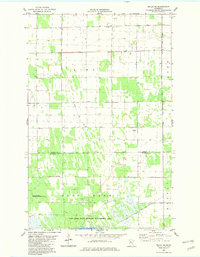
1982 Map of Pelan SE
USGS Topo · Published 1982About this map
Bethlehem Ch and its adjacent Cem anchor the northern landscape of this Roseau County region in the early 1980s. The area is defined by a rigorous network of water management, with County Ditch No 4, Judicial Ditch No 19, and Lateral Ditch No 9 cutting across the townships of Lin D, Deer, and Huntly. The southern portion of the quadrangle is dominated by the East Park State Wildlife Management Area, a conservation expanse that surrounds the marshy waters of Nelson Slough. This survey captures a rural landscape where civil infrastructure, such as the local Townhall, serves as a primary waypoint amidst the intersection of the Roseau Co and Marshall Co border. The map provides clear evidence of the region's heavy reliance on engineered drainage to maintain its agricultural and township boundaries.
Find a feature on this map
12 named features on this map. Tap any name to fly to it.
Don’t see what you’re looking for? This feature index may not catch every label — zoom into the map to look around manually.
Map Details
Editions of this 1982 Pelan SE Map
This is the sole edition of this map. No revisions or reprints were ever made.
Other maps of this area

1918 · Greenbush
USGS Topo · 1:62,500

1918 · Middle River
USGS Topo · 1:62,500

1919 · Pelan
USGS Topo · 1:62,500

1952 · Thief River Falls
USGS Topo · 1:250,000

1956 · Thief River Falls
USGS Topo · 1:250,000

1957 · Thief River Falls
USGS Topo · 1:250,000

1957 · Newfolden
USGS Topo · 1:62,500

1957 · Pelan
USGS Topo · 1:62,500

1962 · Strathcona
USGS Topo · 1:24,000
1962 · Middle River
USGS Topo · 1:24,000