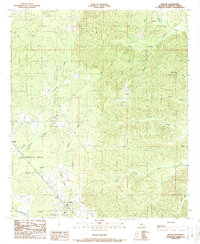
1989 Map of Pelican
USGS Topo · Published 1989About this map
Pelican and Oxford serve as the primary human anchors in this southern De Soto Parish landscape, where colonial-era land divisions meet modern energy extraction. The sprawling Las Ormigas Grant covers a significant portion of the western territory, a reminder of the region’s historical land tenure and Spanish colonial history. This administrative layer exists alongside an active Oil and Gas Field, illustrating the economic shift toward subsurface mineral wealth during the late 20th century.
Find a feature on this map
18 named features on this map. Tap any name to fly to it.
Don’t see what you’re looking for? This feature index may not catch every label — zoom into the map to look around manually.
Map Details
Editions of this 1989 Pelican Map
2 editions found
Other maps of this area

1938 · Chemard Lake
USGS Topo · 1:31,680

1938 · Hollis Creek
USGS Topo · 1:31,680

1941 · Pelican
USGS Topo · 1:62,500

1943 · Pleasant Hill
USGS Topo · 1:62,500

1944 · Pleasant Hill
USGS Topo · 1:62,500

1945 · Mansfield
USGS Topo · 1:62,500

1947 · Mansfield
USGS Topo · 1:62,500

1947 · Hanna
USGS Topo · 1:62,500

1948 · Coushatta
USGS Topo · 1:62,500

1953 · Alexandria
USGS Topo · 1:250,000