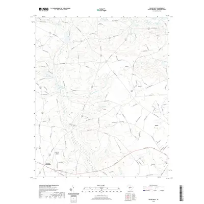
2020 Map of Pelion West
USGS Topo · Published 2020About this map
Pelion and its surrounding countryside in Lexington County are characterized by a dense network of water bodies and family-named landmarks. The landscape is defined by its many impoundments, including Smiths Millpond, Clarks Millpond, and Lucas Millpond, which hint at a history of water-powered industry along the regional creeks. Local heritage is deeply rooted in the numerous rural burial grounds such as Boiling Springs Cem, Black Creek Cem, and Scofield Cem. The presence of the Eagles Nest-Fairview Airpark near Fairview Crossroads illustrates the transition from traditional agrarian land use to modern private aviation hubs. Waterways like Congaree Cr and North Fork Edisto River tributaries weave through a landscape also marked by several family-named ponds, such as Kyser Pond and Harmons Pond, reflecting generations of land ownership.
Find a feature on this map
119 named features on this map. Tap any name to fly to it.
Don’t see what you’re looking for? This feature index may not catch every label — zoom into the map to look around manually.
Map Details
Editions of this 2020 Pelion West Map
This is the sole edition of this map. No revisions or reprints were ever made.
Other maps of this area

1944 · Gilbert
USGS Topo · 1:62,500

1944 · Seivern
USGS Topo · 1:62,500

1944 · Edmund
USGS Topo · 1:62,500

1946 · Woodford
USGS Topo · 1:62,500

1954 · Augusta
USGS Topo · 1:250,000

1957 · Augusta
USGS Topo · 1:250,000

1958 · Augusta
USGS Topo · 1:250,000

1961 · Augusta
USGS Topo · 1:250,000

1962 · Augusta
USGS Topo · 1:250,000
1972 · Lexington
USGS Topo · 1:24,000