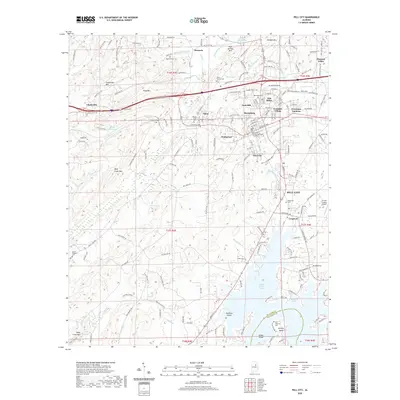
2020 Map of Pell City
USGS Topo · Published 2020About this map
Pell City serves as the focal point of this modern topography, situated within a landscape shaped by both significant ridges and the expansive waters of Logan Martin Lake. The southern portion of the sheet reveals the intricate shoreline of Griffitt Bend and Skippers Cove, while the northern terrain is defined by the high ground of Chulavista Mtn and Savages Mtn. Historical continuity is visible through numerous burial grounds like the Old Florence Cem and Mount Pleasant Cem, offering valuable data for genealogical research. The central corridor is dense with established communities such as Eden, Avondale Village, and Cropwell, reflecting the steady growth of the St. Clair County seat. From the St-Clair County Airport to the various springs and branches like Dunlap Spring Br, the map captures the transition from highland ridges to the managed waters of the Coosa River system.
Find a feature on this map
204 named features on this map. Tap any name to fly to it.
Don’t see what you’re looking for? This feature index may not catch every label — zoom into the map to look around manually.
Map Details
Editions of this 2020 Pell City Map
This is the sole edition of this map. No revisions or reprints were ever made.
Other maps of this area

1889 · Springville
USGS Topo · 1:125,000

1890 · Talladega
USGS Topo · 1:125,000

1892 · Springville
USGS Topo · 1:125,000

1892 · Talladega
USGS Topo · 1:125,000

1943 · Talladega
USGS Topo · 1:62,500

1946 · Talladega
USGS Topo · 1:62,500

1947 · Ragland
USGS Topo · 1:62,500

1947 · Ragland
USGS Topo · 1:24,000

1947 · Riverside
USGS Topo · 1:24,000

1951 · Vincent
USGS Topo · 1:24,000