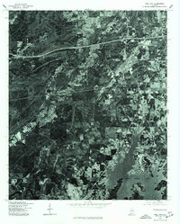
1975 Map of Pell City
USGS Topo · Published 1977About this map
Pell City serves as the focal point of this mid-1970s orthophotoquad, which uses aerial photography to document the landscape of St. Clair County. The imagery reveals the intricate relationship between the developing urban grid of the city and the vast reach of Logan Martin Lake to the south. This transition from dense woodland and cleared agricultural tracts to the expanding suburban fingers of the community is clearly visible. The photograph, captured in early December, provides an unobstructed view of the region's transportation corridors, including the prominent interstate highway crossing the northern portion of the sheet. For those studying the environmental and infrastructural evolution of Alabama, this map documents the area during a period of significant growth after the impoundment of the Coosa River.
Find a feature on this map
2 named features on this map. Tap any name to fly to it.
Don’t see what you’re looking for? This feature index may not catch every label — zoom into the map to look around manually.
Map Details
Editions of this 1975 Pell City Map
This is the sole edition of this map. No revisions or reprints were ever made.
Other maps of this area

1889 · Springville
USGS Topo · 1:125,000

1890 · Talladega
USGS Topo · 1:125,000

1892 · Springville
USGS Topo · 1:125,000

1892 · Talladega
USGS Topo · 1:125,000

1943 · Talladega
USGS Topo · 1:62,500

1946 · Talladega
USGS Topo · 1:62,500

1947 · Ragland
USGS Topo · 1:62,500

1947 · Ragland
USGS Topo · 1:24,000

1947 · Riverside
USGS Topo · 1:24,000

1951 · Vincent
USGS Topo · 1:24,000