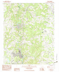
1983 Map of Pelzer
USGS Topo · Published 1983About this map
The Saluda River serves as the primary geographical divider between Greenville and Anderson Counties, where the industrial settlements of Pelzer, West Pelzer, and Piedmont developed along its banks. This 1983 survey shows a landscape transitioning from textile and river-based industry toward a modern suburban and transport-oriented corridor. Two major rail lines, the Seaboard Coast Line and the Southern, parallel the river, while Augusta Road anchors the eastern half of the map near the Donaldson Center Airport (Abandoned). Numerous rural churches and family-named landmarks populate the area, including New Golden Grove Ch and Rehobeth Ch, reflecting the dense network of small communities that historically supported local agriculture and the mills. The topography is defined by significant drainage systems like Grove Creek and Hurricane Creek, which feed into the Saluda valley.
Find a feature on this map
41 named features on this map. Tap any name to fly to it.
Don’t see what you’re looking for? This feature index may not catch every label — zoom into the map to look around manually.
Map Details
Editions of this 1983 Pelzer Map
2 editions found
Other maps of this area

1888 · Pickens
USGS Topo · 1:125,000

1894 · Pickens
USGS Topo · 1:125,000

1935 · Greenville
USGS Topo · 1:48,000

1938 · Greenville
USGS Topo · 1:62,500

1954 · Greenville
USGS Topo · 1:250,000

1957 · Greenville
USGS Topo · 1:24,000

1957 · Anderson
USGS Topo · 1:62,500

1957 · Easley
USGS Topo · 1:62,500

1957 · Williamston
USGS Topo · 1:62,500

1957 · Greenville
USGS Topo · 1:62,500