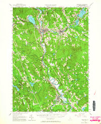
1956 Map of Penacook
USGS Topo · Published 1964About this map
The confluence of the Pemigewasset River and the Winnipesaukee River forms the headwaters of the Merrimack River at Franklin, a central hub for industrial and agricultural activity in the mid-1950s. The landscape is deeply tied to the legacy of one of its most famous residents, marked by the Daniel Webster Birthplace and the Daniel Webster Home for Children nearby. Transportation networks define the valley, with the Boston and Maine Railroad and the Claremont and Concord Railway tracking the watercourses through towns like Boscawen and Tilton.
Find a feature on this map
108 named features on this map. Tap any name to fly to it.
Don’t see what you’re looking for? This feature index may not catch every label — zoom into the map to look around manually.
Map Details
Editions of this 1956 Penacook Map
3 editions found

Other maps of this area

1909 · Winnepesaukee
USGS Topo · 1:62,500

1919 · Gilmanton
USGS Topo · 1:62,500

1921 · Suncook
USGS Topo · 1:62,500

1925 · Holderness
USGS Topo · 1:62,500

1926 · Hillsboro
USGS Topo · 1:62,500

1927 · Concord
USGS Topo · 1:62,500

1927 · Penacook
USGS Topo · 1:62,500

1927 · Gilmanton
USGS Topo · 1:62,500

1927 · Holderness
USGS Topo · 1:62,500

1927 · Cardigan
USGS Topo · 1:62,500