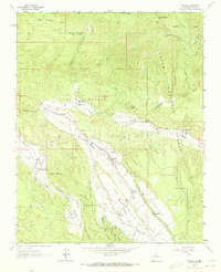
1964 Map of Penasco
USGS Topo · Published 1973About this map
The Picuris Mountains rise above a landscape defined by ancestral land grants and traditional irrigation systems in northern New Mexico. This region is anchored by the Picuris Pueblo, where the San Lorenzo Ch and San Lorenzo Cem represent centuries of community history. The settlement pattern follows the fertile valleys of the Rio Pueblo and Rio Santa Barbara, where a network of gravity-fed ditches like the Acequia Madre de Santa Barbara and Acequia del Llano de la Yegua sustain local agriculture. Small mountain villages such as Peñasco, Rodarte, and Llano are densely packed with family landmarks, including the Virgilio Trujillo Cem and the Morada Cem. The presence of several churches, from the United Emanuel Ch to the St Anthony Ch, highlights the cultural center of these rural townships. Steep terrain is navigated by a complex system of pack trails and early telephone lines that cross the Carson National Forest boundary.
Find a feature on this map
57 named features on this map. Tap any name to fly to it.
Don’t see what you’re looking for? This feature index may not catch every label — zoom into the map to look around manually.
Map Details
Editions of this 1964 Penasco Map
2 editions found
Other maps of this area

1953 · Truchas
USGS Topo · 1:24,000

1953 · Trampas
USGS Topo · 1:24,000

1954 · Raton
USGS Topo · 1:250,000

1958 · Raton
USGS Topo · 1:250,000

1961 · Carson
USGS Topo · 1:24,000

1964 · Tres Ritos
USGS Topo · 1:24,000

1964 · Ranchos De Taos
USGS Topo · 1:24,000

1964 · Penasco
USGS Topo · 1:24,000

1964 · Taos SW
USGS Topo · 1:24,000
1964 · Jicarita Peak
USGS Topo · 1:24,000