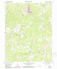
1968 Map of Pendleton
USGS Topo · Published 1987About this map
The South Anna River snakes across this portion of Louisa County, defining a landscape of wooded ridges and small agricultural crossroads as they appeared in the late 1960s. The village of Pendleton serves as a key local hub along the CSX railroad line, while the junction at Cuckoo remains a distinct center of settlement near Roadside Park. This era of the landscape is marked by the creation of the Northeast Creek Reservoir, which altered the drainage patterns of the northern creeks. Local community life is centered around rural institutions like Richardson High Sch, Eagle Ch, and Ebenezer Ch. Significant updates from 1984, shown in purple, document shifts in woodland cover and infrastructure, such as pipelines and a Jeep Trail, providing a clear record of the transition from traditional farming toward more modern land use.
Find a feature on this map
28 named features on this map. Tap any name to fly to it.
Don’t see what you’re looking for? This feature index may not catch every label — zoom into the map to look around manually.
Map Details
Editions of this 1968 Pendleton Map
2 editions found
Other maps of this area

1887 · Spottsylvania
USGS Topo · 1:125,000

1890 · Goochland
USGS Topo · 1:125,000

1891 · Palmyra
USGS Topo · 1:125,000

1892 · Spottsylvania
USGS Topo · 1:125,000

1892 · Goochland
USGS Topo · 1:125,000

1892 · Gordonsville
USGS Topo · 1:125,000

1895 · Palmyra
USGS Topo · 1:125,000

1897 · Palmyra
USGS Topo · 1:125,000

1942 · Mineral
USGS Topo · 1:31,680

1942 · Contrary Creek
USGS Topo · 1:31,680