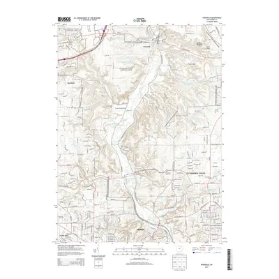
2013 Map of Peninsula
USGS Topo · Published 2013About this map
The Cuyahoga River corridor defines this landscape, winding through a valley deeply etched by geological features like the Ritchie Ledges and Boston Ledges. This modern era of preservation is centered on the Cuyahoga Valley National Park, which encompasses significant local history through landmarks like the Everett Road Bridge and the Furnace Run Aqueduct. The transition from rural valley to suburban centers is evident as the map moves from the village of Peninsula toward the expanding residential areas of Cuyahoga Falls, Akron, and Fairlawn. Numerous small waterways, including Furnace Run, Yellow Creek, and Slipper Run, feed into the main river basin. For genealogists, the map provides precise locations for several burial grounds, from the Cedar Grove Cem in the north to the large Rose Hill Burial Park and Chestnut Memorial Cem in the southern reaches.
Find a feature on this map
86 named features on this map. Tap any name to fly to it.
Don’t see what you’re looking for? This feature index may not catch every label — zoom into the map to look around manually.
Map Details
Editions of this 2013 Peninsula Map
This is the sole edition of this map. No revisions or reprints were ever made.
Other maps of this area

1903 · Cleveland
USGS Topo · 1:62,500

1903 · Akron
USGS Topo · 1:62,500

1905 · Akron
USGS Topo · 1:62,500

1906 · Kent
USGS Topo · 1:62,500

1906 · Chagrin Falls
USGS Topo · 1:62,500

1908 · Chagrin Falls
USGS Topo · 1:62,500

1950 · Cleveland
USGS Topo · 1:250,000

1953 · Broadview Heights
USGS Topo · 1:24,000

1953 · Twinsburg
USGS Topo · 1:24,000
1953 · Northfield
USGS Topo · 1:24,000