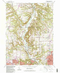
1994 Map of Peninsula
USGS Topo · Published 1997About this map
The Cuyahoga River carves a deep valley through this landscape, flanked by the sprawling Cuyahoga Valley National Recreation Area. The map details a transition from the village centers of Peninsula and Boston Heights toward the industrial fringes of northern Akron and Cuyahoga Falls. Traces of the region's transport history remain visible in the path of the Ohio Canal and established routes like Portage Path.
Find a feature on this map
71 named features on this map. Tap any name to fly to it.
Don’t see what you’re looking for? This feature index may not catch every label — zoom into the map to look around manually.
Map Details
Editions of this 1994 Peninsula Map
This is the sole edition of this map. No revisions or reprints were ever made.
Other maps of this area

1903 · Cleveland
USGS Topo · 1:62,500

1903 · Akron
USGS Topo · 1:62,500

1905 · Akron
USGS Topo · 1:62,500

1906 · Kent
USGS Topo · 1:62,500

1906 · Chagrin Falls
USGS Topo · 1:62,500

1908 · Chagrin Falls
USGS Topo · 1:62,500

1950 · Cleveland
USGS Topo · 1:250,000

1953 · Broadview Heights
USGS Topo · 1:24,000

1953 · Twinsburg
USGS Topo · 1:24,000
1953 · Northfield
USGS Topo · 1:24,000