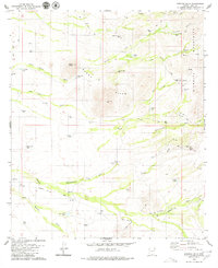
1979 Map of Penitas Hills
USGS Topo · Published 1980About this map
Sierrita Mountains and the Peñitas Hills define the arid topography of this Pima County landscape, where water management is the primary marker of human activity. The map reveals a network of desert infrastructure focused on livestock and small-scale operations, notably at the Peyron Ranch and San Juan Ranch. Dozens of named water catchments and wells, such as the Cinco de Mayo Well, Papago Well, and La Cholla Tank, are linked by a web of unimproved paths and the prominent Batamote Road.
Find a feature on this map
36 named features on this map. Tap any name to fly to it.
Don’t see what you’re looking for? This feature index may not catch every label — zoom into the map to look around manually.
Map Details
Editions of this 1979 Penitas Hills Map
2 editions found
Other maps of this area

1920 · Arivaca
USGS Topo · 1:125,000

1925 · Samaniego Peak
USGS Topo · 1:62,500

1939 · Twin Buttes
USGS Topo · 1:62,500

1939 · Tubac
USGS Topo · 1:62,500

1940 · Palo Alto Ranch
USGS Topo · 1:62,500

1941 · Twin Buttes
USGS Topo · 1:62,500

1941 · Arivaca
USGS Topo · 1:62,500

1943 · Arivaca
USGS Topo · 1:62,500

1943 · Palo Alto Ranch
USGS Topo · 1:62,500

1943 · Tubac
USGS Topo · 1:62,500