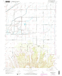
1954 Map of Pennington
USGS Topo · Published 1974About this map
The Sutter Buttes dominate the southern landscape of this 1954 survey, rising sharply from the surrounding Sacramento Valley floor. This topographic study captures the area during a period of significant water management, evidenced by the extensive network of the Cherokee Canal and the Main Drainage Canal that define the agricultural grid. To the north, the Gray Lodge Waterfowl Management Area covers a large expanse of wetlands and managed ponds, with its Headquarters established among the lateral canals. Near the center, the small settlement of Pennington sits at the foot of the volcanic uplands, just east of the North Butte Cemetery. The map detail traces the transition from the rugged peaks and hidden recesses of Peace Valley to the precisely engineered almond orchards and county-line roads, such as Almond Orchard Rd, that characterize the Butte and Sutter county borderlands.
Find a feature on this map
28 named features on this map. Tap any name to fly to it.
Don’t see what you’re looking for? This feature index may not catch every label — zoom into the map to look around manually.
Map Details
Editions of this 1954 Pennington Map
4 editions found
Other maps of this area

1888 · Marysville
USGS Topo · 1:125,000

1891 · Marysville
USGS Topo · 1:125,000

1894 · Marysville
USGS Topo · 1:125,000

1895 · Marysville
USGS Topo · 1:125,000

1911 · Sutter
USGS Topo · 1:31,680

1911 · Sanborn Slough
USGS Topo · 1:31,680

1911 · Landlow
USGS Topo · 1:31,680

1912 · Marysville Buttes
USGS Topo · 1:31,680

1912 · Butte City
USGS Topo · 1:31,680

1912 · Pennington
USGS Topo · 1:31,680