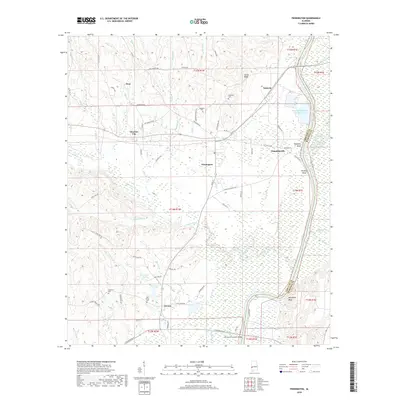
2018 Map of Pennington
USGS Topo · Published 2018About this map
Tuckabum Creek and the sweeping curves of the Tombigbee River define this 2018 survey of eastern Choctaw County. The landscape is marked by a series of prominent riverfront features, including James Bluff, Tompkins Bluff, and Murphys Bluff, which overlook the Marengo Chute along the county line. The map highlights the localized settlement patterns of the late 2010s, from the incorporated town of Pennington to smaller communities such as Tompkinsville and Choctaw City. Industrial and civil infrastructure is evident through the Final Mill Effluent Treatment Pon and the William B Crumpton Bridge, which crosses the southern waterways. Genealogists will find several notable burial sites and local landmarks, such as Millwood Cem, Ebenezer Cem, and Red House Cem, along with the Ebenezer Ch. The network of roads, including Old Naheola Rd and Lotts Ferry Rd, reflects a mix of modern transit and historic river-access routes.
Find a feature on this map
63 named features on this map. Tap any name to fly to it.
Don’t see what you’re looking for? This feature index may not catch every label — zoom into the map to look around manually.
Map Details
Editions of this 2018 Pennington Map
This is the sole edition of this map. No revisions or reprints were ever made.
Other maps of this area

1953 · Montgomery
USGS Topo · 1:250,000

1953 · Meridian
USGS Topo · 1:250,000

1956 · Montgomery
USGS Topo · 1:250,000

1957 · Meridian
USGS Topo · 1:250,000

1957 · Montgomery
USGS Topo · 1:250,000

1965 · Meridian
USGS Topo · 1:250,000

1970 · Myrtlewood North
USGS Topo · 1:24,000

1971 · Whitfield
USGS Topo · 1:24,000

1971 · Gaston
USGS Topo · 1:24,000
1978 · Pennington
USGS Topo · 1:24,000