
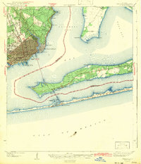
1942 Map of Pensacola
USGS Topo · Published 1942About this map
Pensacola stands as a bustling coastal hub during the early 1940s, its street grid densely mapped and anchored by maritime activity at the Muscogee Wharf. The region's economy and logistics are defined by the Louisville and Nashville railroad corridor, which skirts the edge of Escambia Bay and passes through outlying communities like Gaboronne and Magnolia Bluff. This survey captures the transition from urban centers to the recreational and institutional landscapes of the barrier islands, where a Boy Scout Camp and Girl Scout Camp sit near Gulf Breeze.
Find a feature on this map
55 named features on this map. Tap any name to fly to it.
Don’t see what you’re looking for? This feature index may not catch every label — zoom into the map to look around manually.
Map Details
Editions of this 1942 Pensacola Map
2 editions found
Other maps of this area

1920 · Milton
USGS Topo · 1:62,500

1921 · Holley
USGS Topo · 1:62,500

1921 · Pensacola
USGS Topo · 1:62,500

1921 · Fort Barrancas
USGS Topo · 1:62,500

1921 · Muscogee
USGS Topo · 1:62,500

1934 · Harold
USGS Topo · 1:62,500

1936 · Holley
USGS Topo · 1:48,000

1937 · Harold
USGS Topo · 1:62,500

1938 · Holley
USGS Topo · 1:62,500

1938 · Harold
USGS Topo · 1:62,500