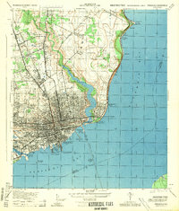
1944 Map of Pensacola
USGS Topo · Published 1944About this map
The deep-water maritime economy of Pensacola is on full display in this mid-century War Department survey, emphasizing the critical infrastructure of the Florida Panhandle during the 1940s. The waterfront is a dense concentration of industrial activity, featuring the L & N Railroad Piers, Baylen Wharf, and the Muscogee Wharf, all linked to the hinterland by the Louisville & Nashville and Frisco rail lines. This network facilitated the movement of goods from the interior to the ships in Pensacola Bay, while the Pensacola Bay Bridge provided a vital highway connection to Santa Rosa County.
Find a feature on this map
37 named features on this map. Tap any name to fly to it.
Don’t see what you’re looking for? This feature index may not catch every label — zoom into the map to look around manually.
Map Details
Editions of this 1944 Pensacola Map
This is the sole edition of this map. No revisions or reprints were ever made.
Other maps of this area

1920 · Milton
USGS Topo · 1:62,500

1921 · Pensacola
USGS Topo · 1:62,500

1921 · Fort Barrancas
USGS Topo · 1:62,500

1921 · Muscogee
USGS Topo · 1:62,500

1941 · Fort Barrancas
USGS Topo · 1:62,500

1941 · Muscogee
USGS Topo · 1:62,500

1941 · Pensacola
USGS Topo · 1:62,500

1941 · Milton
USGS Topo · 1:62,500

1942 · Pensacola
USGS Topo · 1:62,500

1943 · Muscogee
USGS Topo · 1:62,500
Featured Places
- Pensacola, FL
- East Pensacola Heights, Pensacola
- Gull Point, Pensacola
- Sanders Beach, Pensacola
- Brent, FL