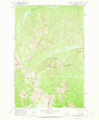
1970 Map of Pentagon Mountain
USGS Topo · Published 1973About this map
The Bob Marshall Wilderness defines this high-elevation landscape, where the Continental Divide weaves between Pentagon Mountain and Table Mountain. This 1970 field-checked survey reveals the complex drainages of the Flathead National Forest and the Lewis and Clark National Forest, marked by the headwaters of the Mid Fk Flathead R and the South Fork Sun River. The terrain is characterized by a network of pack trails connecting significant landmarks like Switchback Pass and the remote waters of Dean Lake and Lake Levale. Within the Sun River Game Preserve, named peaks such as Signal Mountain and Moonlight Peak stand as prominent features of the Front Range. The map effectively documents the administrative boundary between Flathead Co and Lewis and Clark Co as it follows the high ridges of the divide.
Find a feature on this map
27 named features on this map. Tap any name to fly to it.
Don’t see what you’re looking for? This feature index may not catch every label — zoom into the map to look around manually.
Map Details
Editions of this 1970 Pentagon Mountain Map
This is the sole edition of this map. No revisions or reprints were ever made.
Other maps of this area

1903 · Saypo
USGS Topo · 1:125,000

1913 · Marias Pass
USGS Topo · 1:125,000

1914 · Heart Butte
USGS Topo · 1:125,000

1918 · Heart Butte
USGS Topo · 1:125,000

1936 · Silvertip
USGS Topo · 1:96,000

1942 · Silvertip
USGS Topo · 1:125,000

1955 · Choteau
USGS Topo · 1:250,000

1957 · Choteau
USGS Topo · 1:250,000

1958 · Choteau
USGS Topo · 1:250,000

1958 · Gable Peaks
USGS Topo · 1:24,000