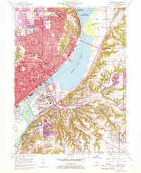
1949 Map of Peoria East
USGS Topo · Published 1968About this map
The Illinois River divides this mid-century landscape, carving a wide path between the bustling industrial and residential core of Peoria and the developing eastern shores of East Peoria and Creve Coeur. A dense network of schools, such as Bradley University, Woodruff High School, and St Cecilia School, reflects a period of significant urban growth and civic investment. The map documents the city's infrastructure at a pivotal moment, showing the Peoria Heights Reservoir and several river crossings including the Cedar St Bridge and Franklin St Bridge.
Find a feature on this map
87 named features on this map. Tap any name to fly to it.
Don’t see what you’re looking for? This feature index may not catch every label — zoom into the map to look around manually.
Map Details
Editions of this 1949 Peoria East Map
5 editions found

Other maps of this area

1893 · Metamora
USGS Topo · 1:62,500

1893 · Dunlap
USGS Topo · 1:62,500

1898 · Dunlap
USGS Topo · 1:62,500

1905 · Peoria
USGS Topo · 1:62,500

1927 · Peoria
USGS Topo · 1:62,500

1928 · Mackinaw
USGS Topo · 1:62,500

1932 · Mackinaw
USGS Topo · 1:62,500

1932 · Dunlap
USGS Topo · 1:62,500

1933 · Dunlap
USGS Topo · 1:62,500

1937 · Metamora
USGS Topo · 1:62,500