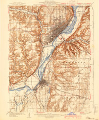
1961 Map of Peoria
USGS Topo · Published 1961This historical map portrays the area of Peoria in 1961, primarily covering Peoria as well as portions of De Witt County, Ford County, Woodford County, Mason County, Cass County, Menard County, Livingston County, Marshall County, Fulton County, Champaign, McLean County, Logan County, Tazewell County, Iroquois County, LaSalle County, Kankakee County, Macon County, Stark County, Knox County, and Piatt County. Featuring a scale of 1:250000, this map provides a highly detailed snapshot of the terrain, roads, buildings, counties, and historical landmarks in the Peoria region at the time. Published in 1961, it is the sole known edition of this map.
Find a feature on this map
105 named features on this map. Tap any name to fly to it.
Don’t see what you’re looking for? This feature index may not catch every label — zoom into the map to look around manually.
Map Details
Editions of this 1961 Peoria Map
This is the sole edition of this map. No revisions or reprints were ever made.
Historical Maps of Mossville Through Time
8 maps found