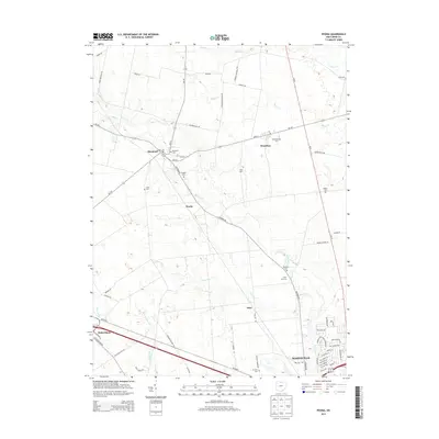
2013 Map of Peoria
USGS Topo · Published 2013About this map
Mill Creek and its various tributaries, including Blues Cr and Otter Run, define the drainage patterns of this Union County landscape northwest of Marysville. The map captures a primarily agricultural region structured around historic hamlets and intersections. Raymond and Broadway serve as local hubs along Oh-347, while the eponymous settlement of Peoria sits central to the quadrangle at the junction of Raymond Rd. For genealogists, the map is a dense record of early local history, marking numerous family-named burial grounds such as Ford Cem, Baughn Cem, and Asbury Cem. The proximity of these small cemeteries to established farm roads like Evans Rd and Barnett Rd suggests a landscape where family lineages remained deeply tied to specific land parcels well into the twenty-first century. Even as Marysville begins to expand in the southeast, the area maintains its rural character through landmarks like Bliss Dairy and Fruit-Full Acres.
Find a feature on this map
70 named features on this map. Tap any name to fly to it.
Don’t see what you’re looking for? This feature index may not catch every label — zoom into the map to look around manually.
Map Details
Editions of this 2013 Peoria Map
This is the sole edition of this map. No revisions or reprints were ever made.
Other maps of this area

1913 · East Liberty
USGS Topo · 1:62,500

1913 · Richwood
USGS Topo · 1:62,500

1914 · Mechanicsburg
USGS Topo · 1:62,500

1915 · Richwood
USGS Topo · 1:62,500

1915 · East Liberty
USGS Topo · 1:62,500

1916 · Mechanicsburg
USGS Topo · 1:62,500

1916 · Milford Center
USGS Topo · 1:62,500

1944 · East Liberty
USGS Topo · 1:62,500

1944 · Mechanicsburg
USGS Topo · 1:62,500

1944 · Richwood
USGS Topo · 1:62,500