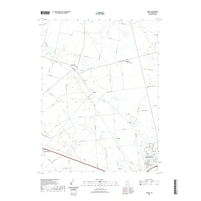
2019 Map of Peoria
USGS Topo · Published 2019About this map
Peoria and its surrounding hamlets sit at a crossroads of rural Union County, defined by a network of drainage ways and local cemeteries that mark the area's ancestral roots. Small communities like Raymond, Broadway, and Pottersburg are interconnected by a grid of county roads, with Mill Creek and Blues Cr winding through the agricultural landscape. The southern portion of the sheet shows the northern expansion of Marysville, where modern suburban street patterns contrast with the traditional rural layout of the northern sections. Numerous family and community burial grounds, such as Asbury Cem and Hamilton Cem, are preserved across the terrain, offering significant touchpoints for genealogists. The map also traces the paths of Otter Run and Bear Swamp Run, illustrating the complex natural hydrology that has influenced the placement of these settlements and farmsteads.
Find a feature on this map
85 named features on this map. Tap any name to fly to it.
Don’t see what you’re looking for? This feature index may not catch every label — zoom into the map to look around manually.
Map Details
Editions of this 2019 Peoria Map
This is the sole edition of this map. No revisions or reprints were ever made.
Other maps of this area

1913 · East Liberty
USGS Topo · 1:62,500

1913 · Richwood
USGS Topo · 1:62,500

1914 · Mechanicsburg
USGS Topo · 1:62,500

1915 · Richwood
USGS Topo · 1:62,500

1915 · East Liberty
USGS Topo · 1:62,500

1916 · Mechanicsburg
USGS Topo · 1:62,500

1916 · Milford Center
USGS Topo · 1:62,500

1944 · East Liberty
USGS Topo · 1:62,500

1944 · Mechanicsburg
USGS Topo · 1:62,500

1944 · Richwood
USGS Topo · 1:62,500