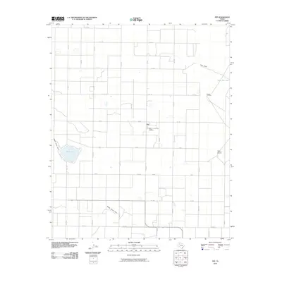
2010 Map of Pep
USGS Topo · Published 2010About this map
Pep stands as a primary settlement within this West Texas landscape, defined by a rigid grid of rural roads and the dramatic natural hydrology of the High Plains. The community is anchored by the Saint Phillips Cemetery, reflecting the local history of the area's residents. The terrain is marked by significant drainage features, most notably Yellow House Draw and Goat Draw, which cut across the plateau. Water management in this semi-arid environment is evident through features like Silver Lake, Upper Goat Tank, and strategically placed landmarks such as Double Windmills and South Twomile Windmill. The road network is a mixture of farm-to-market routes like FM 303 and named thoroughfares such as Topeka Ave and Ontario, illustrating the intersection of agricultural planning and transport across Hockley County.
Find a feature on this map
33 named features on this map. Tap any name to fly to it.
Don’t see what you’re looking for? This feature index may not catch every label — zoom into the map to look around manually.
Map Details
Editions of this 2010 Pep Map
This is the sole edition of this map. No revisions or reprints were ever made.
Other maps of this area

1954 · Brownfield
USGS Topo · 1:250,000

1958 · Brownfield
USGS Topo · 1:250,000

1962 · Brownfield
USGS Topo · 1:250,000

1964 · Oklahoma Flat
USGS Topo · 1:24,000
1964 · Bull Lake
USGS Topo · 1:24,000

1964 · Pep
USGS Topo · 1:24,000
1964 · Beck
USGS Topo · 1:24,000

1965 · Hester Ranch
USGS Topo · 1:24,000

1965 · Pettit
USGS Topo · 1:24,000
1968 · Bula
USGS Topo · 1:24,000