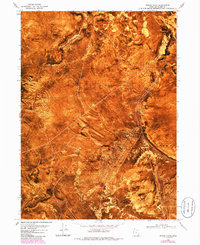
1969 Map of Peplin Flats
USGS Topo · Published 1985About this map
Central Pacific Railroad Grade remnants traverse this high desert landscape, marking the historic path of the first transcontinental line through Box Elder County. This orthophotomap, based on 1969 aerial photography and updated with 1982 revisions, provides a literal overhead view of the arid terrain where the Old Central Pacific Railroad Grade skirts the northern edge of the Peplin Flats. The map identifies Ombey (Site), a former station or settlement point along the corridor, situated between the Baker Hills and the southern slopes of Baker Mountain. The scarcity of water is evident in the scattered and specifically named sources like Peplin Pond, Mineral Spring, and Springs (Salt). These points of interest, combined with the distinct geological forms of Table Mtn and Peplin Mtn, illustrate the logistical challenges faced by early railroad engineers in the Great Basin.
Find a feature on this map
19 named features on this map. Tap any name to fly to it.
Don’t see what you’re looking for? This feature index may not catch every label — zoom into the map to look around manually.
Map Details
Editions of this 1969 Peplin Flats Map
3 editions found
Other maps of this area

1954 · Brigham City
USGS Topo · 1:250,000

1958 · Brigham City
USGS Topo · 1:250,000

1959 · Kelton Pass
USGS Topo · 1:62,500

1959 · Park Valley
USGS Topo · 1:62,500

1962 · Brigham City
USGS Topo · 1:250,000

1969 · Peplin Flats
USGS Topo · 1:24,000

1969 · Crocodile Mtn NE
USGS Topo · 1:24,000

1969 · Hogup Bar
USGS Topo · 1:24,000
1969 · Crocodile Mtn SE
USGS Topo · 1:24,000

1971 · Matlin
USGS Topo · 1:24,000