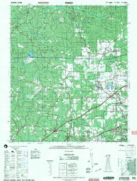
2002 Map of Perdido
USGS Topo · Published 2002About this map
Booneville and Lottie anchor this corner of the Alabama coastal plain, where the landscape is defined by the winding course of the Little River and the rural boundary between Baldwin and Escambia counties. The area exhibits a pattern of small settlements and family-named landmarks that have persisted through generations, such as McCullough and Poarch. This survey reveals the agricultural and timber-driven nature of the region at the turn of the millennium, characterized by scattered Mines and numerous country parishes like Friendly Church and Lindsey Church.
Find a feature on this map
48 named features on this map. Tap any name to fly to it.
Don’t see what you’re looking for? This feature index may not catch every label — zoom into the map to look around manually.
Map Details
Editions of this 2002 Perdido Map
This is the sole edition of this map. No revisions or reprints were ever made.
Other maps of this area

1941 · Bay Minette
USGS Topo · 1:62,500

1941 · Century
USGS Topo · 1:62,500

1942 · Perdido
USGS Topo · 1:62,500

1942 · Dyas
USGS Topo · 1:62,500

1943 · Century
USGS Topo · 1:62,500

1943 · Bay Minette
USGS Topo · 1:62,500

1943 · Choctaw Bluff
USGS Topo · 1:62,500

1943 · Tensaw
USGS Topo · 1:62,500

1944 · Tensaw
USGS Topo · 1:62,500

1944 · Dyas
USGS Topo · 1:62,500