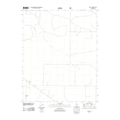
2010 Map of Perico
USGS Topo · Published 2010About this map
Perico is situated in the high plains of the Texas Panhandle, where the drainage of Rita Blanca Creek and its tributaries, West Rita Blanca Creek and East Rita Blanca Creek, define the subtle topography. The landscape is marked by a rigid grid of rural routes and farm-to-market roads, including family-named landmarks such as Metcalf Rd and Brewster Ln. In the southern portion of the quadrangle, the Nebtex Land Company Airport serves as a reminder of the region's large-scale agricultural and ranching operations, which have long shaped the local economy. The network of naming conventions seen in roads like C and M Ln and O Bar Ln suggests the deep-rooted ranching heritage of Dallam County, reflecting the property lines and access routes of historical landholdings in this open prairie environment.
Find a feature on this map
14 named features on this map. Tap any name to fly to it.
Don’t see what you’re looking for? This feature index may not catch every label — zoom into the map to look around manually.
Map Details
Editions of this 2010 Perico Map
This is the sole edition of this map. No revisions or reprints were ever made.
Other maps of this area

1954 · Dalhart
USGS Topo · 1:250,000

1958 · Dalhart
USGS Topo · 1:250,000

1962 · Dalhart
USGS Topo · 1:250,000

1973 · Buffalo Springs
USGS Topo · 1:24,000

1973 · Wharton Ranch
USGS Topo · 1:24,000

1973 · Tovrea Ranch
USGS Topo · 1:24,000

1973 · Corlena
USGS Topo · 1:24,000

1973 · Perico
USGS Topo · 1:24,000
1973 · Corlena NW
USGS Topo · 1:24,000

1973 · Bolin
USGS Topo · 1:24,000