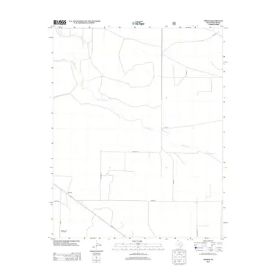
2012 Map of Perico
USGS Topo · Published 2012About this map
Perico serves as the primary landmark in this corner of the Texas Panhandle, positioned along a major transit line through Dallam County. The landscape is defined by the branching drainage system of Rita Blanca Cr, including its northern tributaries E Rita Blanca Cr and W Rita Blanca Cr. The map reveals a structured grid of rural roads named for local families and agricultural interests, such as Metcalf Rd, Brewster Ln, and O Bar Ln. This 2012 survey illustrates the enduring nature of the high plains ranching economy, where small-scale infrastructure like the Nebtex Land Co. Airport provides essential connectivity for remote land management operations far from the county's larger population centers.
Find a feature on this map
14 named features on this map. Tap any name to fly to it.
Don’t see what you’re looking for? This feature index may not catch every label — zoom into the map to look around manually.
Map Details
Editions of this 2012 Perico Map
This is the sole edition of this map. No revisions or reprints were ever made.
Other maps of this area

1954 · Dalhart
USGS Topo · 1:250,000

1958 · Dalhart
USGS Topo · 1:250,000

1962 · Dalhart
USGS Topo · 1:250,000

1973 · Buffalo Springs
USGS Topo · 1:24,000

1973 · Wharton Ranch
USGS Topo · 1:24,000

1973 · Tovrea Ranch
USGS Topo · 1:24,000

1973 · Corlena
USGS Topo · 1:24,000

1973 · Perico
USGS Topo · 1:24,000
1973 · Corlena NW
USGS Topo · 1:24,000

1973 · Bolin
USGS Topo · 1:24,000